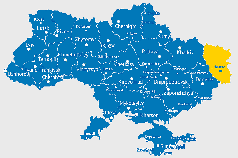
Ukraine political map, Ukrainian regions, world map area, travel Ukraine, European geography, cartography visualization, geopolitical boundaries, PNG free download
Ukraine political map, Ukrainian regions, world map area, travel Ukraine, European geography, cartography visualization, geopolitical boundaries
More related PNGs
850x550pxblue world map, early cartography atlas, political map collection, world map line art, global geography illustration, international map design, earth continent layout
1062x399pxIndonesian Map, red map outline, travel World, cartography, Southeast Asia geography, archipelago nation, island nation map
1024x1024pxglobe silhouette, equirectangular projection map, earth icon logo, world map projection, global geography illustration, international cartography design, planet earth visual
1280x580pxred and white map illustration, Flag of Indonesia Brunei Map, greater Indonesia map, blank map with flag design, Southeast Asia political map, cartographic design elements, regional geography illustration
3608x2189pxlocation-based service, True Phantom Solutions, mobile phone mapping, travel world navigation, digital map pin, geolocation technology, area mapping service
3001x1099pxgrey Indonesia map, blank globe illustration, monochrome country map, flat design travel map, Southeast Asia geography, archipelago outline, island nation cartography
7506x8000pxIndia blank map, orange India silhouette, India world map design, stock India map, Indian geography outline, map of South Asia, India political borders
4167x2084pxIndonesia map, flat design map, yellow and blue map, travel world map, geographic layout, island nation map, southeast asia cartography
1100x569pxworld map illustration, dot distribution map, seven continents map, travel around the world, global connectivity, international routes, world geography diagram
720x720pxUkraine map with flag, Ukrainian national colors, contour line of Ukraine, yellow and blue map, Ukrainian geography, Eastern European borders, Ukrainian travel guide
1427x845pxworld map, flat design map, cartography globe, geography map, global travel map, earth atlas, international map design
544x488pxUkraine map silhouette, black and white Ukraine map, Ukrainian fauna map, travel Ukraine map, geographic outline of Ukraine, Ukrainian landscape illustration, Eastern European cartography
1000x1000pxUkraine map, yellow and blue, travel Ukraine, Ukrainian symbol, Eastern European country, national flag design, geopolitical region
700x838pxIndia Map illustration, India political map, blank India map, India state boundaries, Indian subcontinent geography, South Asia cartography, detailed India region map
1280x801pxFlag of the United States Map, national Flag of USA, travel World with US flag, geography of the United States, American patriotic symbols, USA map design, stars and stripes layout
1411x550pxIndonesia Map, blue map, travel World, aqua design, Southeast Asia geography, archipelago visualization, cartographic representation
2000x1367pxFlag of Mexico Map, Mexican flag overlay, travel Mexico, world map with flag, Mexican cartography, national emblem map, geographic flag design
900x900pxKarnataka Legislative Assembly election map, India political map, yellow Karnataka outline, Karnataka election results map, Indian state boundaries, regional election visualization, political geography of Karnataka
2640x1674px7 continent world map, color world map, flat world map, world map diagram, global geography map, international travel map, world map infographic
1024x585pxIndonesia map with flag, Indonesian national symbols, red and white map illustration, Flag of Indonesia overlay, Southeast Asia cartography, Indonesian geography visuals, patriotic map design
2602x1952pxEurope political map, European globe map, world geography, European area map, European continent map, European countries outline, European map illustration
1001x555pxRussia political map, карта россии, world map cartography, mapa polityczna Russia, Russian federation regions, geopolitical boundaries, Eurasian territories
1800x983pxworld map mercator projection, asia ocean map, flat earth globe map, robinson projection world, global geography chart, earth cartography design, world atlas illustration
668x668pxspherical Earth, globe world map, earth science concepts, flat Earth debate, global geography visuals, planetary view from space, environmental science
736x507pxRussia orange map, Russian city map, blank Russia map, scale map of Russia, Russian geography, political map of Russia, Russian urban areas
1280x640pxUkraine flag, Ukrainian national colors, Ukraine map outline, blue and yellow flag, Eastern European symbols, national identity markers, patriotic, png
1200x1200pxUkraine flag, electric blue and yellow, Ukrainian national symbol, world flag collection, Ukrainian independence, European nation emblem, patriotic colors design
860x698pxworld map illustration, colorful world map, flat design map, world map continents, global geography, world map infographic, international travel map
1667x1667pxworld map, flat color world map, world map material, color map of the world, global geography illustration, international cartography design, world atlas graphic
925x520pxblue dot world map, global map with dots, flat Earth diagram, blue abstract globe, world map design, international travel map, digital cartography
892x906pxBrazil regions map, blank Brazil map, political map of Brazil, ecoregions of Brazil, South American geography, Brazilian states outline, map of Brazilian territories
742x866pxSouth America map, Latin America political map, blank Americas map, latino integration, South American geography, political boundaries Americas, continental map analysis
578x578pxBrazil map, black and white map, mapa polityczna, travel world, South America geography, political division, country borders
1500x1500pxEurope Map, black and white map, silhouette map, travel world, European countries, geographic outline, continent illustration
900x900pxNizamabad District Map, Telangana State Outline, India Political Map, Yellow Region Highlight, Geographical Borders, Administrative Division, Regional Cartography
1024x377pxFlag of Indonesia Map, black and white map, Indonesia line art, monochrome travel map, Southeast Asia geography, archipelago illustration, political boundaries
2100x1313pxblue world map, cloud map, mappa Mundi, world map stock, pixelated map, global geography, digital cartography
720x720pxEarth Globe Illustration, World Map HD, Travel World Map, Planet Earth Grid, Global Geography, Terrestrial Sphere, Continental Atlas
587x600pxGlobe World Earth Emoji, Africa continent map, sphere planet icon, world map projection, global geography illustration, earth emoji graphic, international cartography design
6599x3245pxyellow world map, globe illustration, world map background, travel around the world, global geography, earth continents, international map design
1024x838pxAmerican flag map, USA patriotic banner, United States flag design, travel world USA, American stars and stripes, USA flag silhouette, American flag geography
1100x479pxwhite and teal island illustration, United States continent map, beautiful world map design, seven continents map, global cartography art, 3D world geography, international travel map
1600x1135pxworld map illustration, mercator projection map, elegant world map design, political world map, global geography infographic, international borders visualization, earth continents layout
1280x800px3D Earth globe, world map sphere, raised relief map, geo information system, global geography, planet earth visualization, continental landmasses
1486x610pxFlag of Indonesia Map, Indonesian travel map, blue world map, Indonesian area map, Southeast Asia map, country outline map, travel destination map
2400x1800pxMaharashtra Map illustration, UK geography, monochrome area diagrams, line art states, geographic boundary outlines, regional cartography design, geopolitical zone mapping
1000x550pxMalaysia blank map, Malaysia map, travel world map, geography map, Southeast Asia map, dot pattern map, green background map
1667x1667pxblue dotted world map, world map pattern design, travel around the world map, polka dots globe illustration, geopolitical area map, fantasy map geography concept, aqua dot distribution cartography
1060x660pxEurope blank map, monochrome world map, black and white geography, cartography europe, political map analysis, continental borders visualization, geographic layout study
5748x5852pxEarth World Globe, Cartoon World Map, green planet illustration, free content globe image, global geography graphic, world atlas visual, spherical earth depiction
2455x1318pxworld map mercator projection, flat earth society globe, black and white cartography, early world maps design, global geography illustration, continental layout visualization, historical cartographic art
359x768pxArgentina blank map, Argentine Northwest geography, black and white outline, coloring book map, South American cartography, silhouette map, travel atlas design
2339x1377pxRussia Map silhouette, black and white Russia map, blank Russia map, monochrome world map, Russian geography outline, Eurasian landmass shape, northern hemisphere cartography
1437x1495pxAsia continental map, Asia Europe globe, mercator projection map, blank Asia map, world geography, global cartography, continental boundaries
1000x526pxgray world map, dot distribution map, monochrome globe, black and white cartography, global geography illustration, international point map, world atlas design
2000x855pxFlag of Indonesia Map, Indonesian travel map, world map design, area map of Indonesia, Southeast Asia map, political map of Indonesia, Indonesian geography illustration
2268x2000pxworld map, old map, parchment map, travel around the world, vintage world map, global geography, historical cartography
1280x1280pxPalestine map, Gaza region, Palestinian flag, Middle East conflict, territorial boundaries, geopolitical area, national identity, png
600x424pxFlag of Indonesia Map, peta Indonesia, world map, blue area, Indonesian geography, archipelagic nation, Southeast Asia cartography
1213x512pxblue world map, Mercator Projection map, world geography illustration, mapa Mundi drawing, global cartography, international atlas, earth visualization
518x518pxMalvinas Argentinas map, Falkland Islands dispute, Argentine Antarctica territory, blue world map, southern hemisphere islands, territorial sovereignty conflict, Antarctic region geopolitics
498x560pxLatin America map, South America political map, black and white Americas map, world map with Latin America, geographic layout of South America, political boundaries of Latin America, monochrome continent map
1491x1600pxAfrica map with flags, African national flags, world map with country flags, pan-African flag design, African political boundaries, continent flag collage, African cultural symbols
5136x3072pxAntarctica map HD, Map of the world exquisite, world Cup travel, plate world map, global geographical visualization, high-resolution world atlas, seven continents cartography
980x618pxblack silhouette USA map, blank United States map, monochrome map of USA, travel world map USA, geographic outline of America, continental United States shape, minimalist USA cartography
500x500pxMaharashtra blank map, black and white silhouette, travel world map, stock map image, geographic outline, state boundary illustration, cartographic design
1400x960pxstate border of Ukraine, Ukrainian Soviet Socialist Republic map, Carpatho-Ukraine territory, blank map of Ukraine, historical Ukrainian borders, geopolitical map analysis, Eastern European cartography
2290x2285pxFlag of Greece map, Greek national symbol, Greece travel world map, Greek flag overlay, Hellenic geography, Mediterranean country borders, Aegean region cartography
500x721pxPeru political map, Lima city map, black and white world map, map of Peru, South America geography, country borders illustration, travel destination guide
2937x2645pxBrazil regions map, South Region Brazil geography, Southeast Region Brazil political division, North Region Brazil ecoregion, Brazilian state boundaries, map of Brazilian territories, Brazilian regional subdivisions
500x500pxblue globe map, world sphere icon, isolated earth image, desktop world map, global geography illustration, planet cartography graphic, international atlas design
1100x1024pxFlag of Poland, Polish flag map, Polish map outline, Poland travel guide, European national flags, red and white emblem, geopolitical illustration
1200x630pxIndonesia flag map, red and white country illustration, Pembela Tanah Air map, Indonesian national symbol, Southeast Asia cartography, patriotic design elements, historical geography visuals
800x738pxAustralia monochrome map, black silhouette world map, Australia blank map, geography atlas, Australian continent outline, global monochrome cartography, earth silhouette illustration