India states and territories map, blank India map, India political map, India regions map, Indian subcontinent map, India administrative divisions, India geography map, PNG free download
India states and territories map, blank India map, India political map, India regions map, Indian subcontinent map, India administrative divisions, India geography map
850x550pxblue world map, early cartography atlas, political map collection, world map line art, global geography illustration, international map design, earth continent layout
700x700pxIndia silhouette map, India map drawing, India world map, India map design, Indian subcontinent outline, South Asia map illustration, India geographic shape
7506x8000pxIndia blank map, orange India silhouette, India world map design, stock India map, Indian geography outline, map of South Asia, India political borders
1280x580pxred and white map illustration, Flag of Indonesia Brunei Map, greater Indonesia map, blank map with flag design, Southeast Asia political map, cartographic design elements, regional geography illustration
576x644pxIndian flag map, Independence Day illustration, tricolor India design, Falun India icon, patriotic map graphic, national symbol art, independence celebration
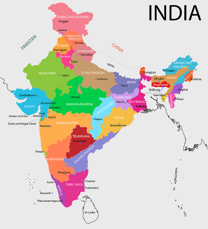
700x838pxIndia Map illustration, India political map, blank India map, India state boundaries, Indian subcontinent geography, South Asia cartography, detailed India region map
1280x684pxRussian Revolution map, Flag of Russia, Russia topo map, blue flag, Russian historical map, Soviet era map, Russian political divisions
3001x1099pxgrey Indonesia map, blank globe illustration, monochrome country map, flat design travel map, Southeast Asia geography, archipelago outline, island nation cartography
603x1024pxLion Capital of Ashoka, Satyameva Jayate, State Emblem of India, monochrome logo, Indian national symbols, Ashoka pillar iconography, heritage art illustration
1280x1584pxFlag of Germany, Allied-occupied Germany Map, blank Map, red yellow black, German territorial divisions, historical Germany map, post-war Germany borders
1200x1200pxIndia monochrome map, Indian silhouette map, blank India map, black and white India map, India geographic outline, India country shape, India border illustration
892x906pxBrazil regions map, blank Brazil map, political map of Brazil, ecoregions of Brazil, South American geography, Brazilian states outline, map of Brazilian territories
500x849pxGovernment of India emblem, Ministry of Agriculture logo, Farmers Welfare symbol, Indian state seal, Ashoka Chakra icon, agricultural policy illustration, national governance
900x900pxKarnataka Legislative Assembly election map, India political map, yellow Karnataka outline, Karnataka election results map, Indian state boundaries, regional election visualization, political geography of Karnataka
900x900pxNizamabad District Map, Telangana State Outline, India Political Map, Yellow Region Highlight, Geographical Borders, Administrative Division, Regional Cartography
675x421pxMaharashtra map, Maharashtra state outline, Maharashtra geography, Maharashtra region, India state maps, map of Indian states, Maharashtra borders, png
760x783pxNarendra Modi portrait, Indian Prime Minister image, Bharatiya Janata Party leader, political figure in India, Indian statesman, formal attire, distinguished leader
444x701pxEngland Map UK, flag of the United Kingdom, map of Great Britain, blue and red design, British geography, UK political division, Union Jack overlay
510x540pxIndia Globe Map, India world map, orange India map, blank India map, geographical representation, cartographic design, subcontinent outline
1280x801pxFlag of the United States Map, national Flag of USA, travel World with US flag, geography of the United States, American patriotic symbols, USA map design, stars and stripes layout
1200x641pxRussia blank map, black and white Russia map, monochrome Russia map, white Russia map, Russian geography, political map of Russia, Russia outline map
900x900pxKerala Map, India silhouette, blank Kerala map, travel Kerala, South India state, geographical outline, blue region map
1425x1199pxChina flag map, Flag of China blank map, red China map, Chinese flag stars, China political map, China geography illustration, China national symbol design
2000x5697pxPalestine Flag Map, State of Palestine Map, Mandatory Palestine Flag, Palestine Flag Artwork, Middle East Political Map, Arab Flag Design, Historical Palestine Territory
2400x1190pxworld map, blank map, natural Earth, global geography, earth continents, international atlas
595x689pxIndia blank map, political map of India, outline of India, white line map, geographical visualization, country borders, subcontinent layout
2000x2171pxTamil Nadu Government Seal, Tamil Nadu Legislative Assembly emblem, State Emblem of India, gopuram temple illustration, Indian state symbols, Tamil Nadu official logo, South Indian government insignia
736x507pxRussia orange map, Russian city map, blank Russia map, scale map of Russia, Russian geography, political map of Russia, Russian urban areas
910x683pxNarendra Modi portrait, International Day of Yoga celebration, Prime Minister of India, professional leader, Indian political figure, smiling elder statesman, traditional attire display
450x600pxState Emblem of India, Ashok Stambh, national symbol India, lion illustration, Indian cultural icon, historical emblem design, golden lion sculpture
943x1091pxblank India map, states and territories of India outline, monochrome Indian political map, central India geography, Indian borderlines illustration, subcontinental regions layout, location markers on India无声無息无声无息无声无息China
578x578pxBrazil map, black and white map, mapa polityczna, travel world, South America geography, political division, country borders
742x866pxSouth America map, Latin America political map, blank Americas map, latino integration, South American geography, political boundaries Americas, continental map analysis
1000x1000pxIndian flag circular design, orange white green tricolor, national symbols of India, Ashoka Chakra emblem, Indian independence symbol, patriotic emblem, sovereign state insignia
1115x1280pxIndia flag map, Indian national symbol, tricolor India map, blank India map, political map of India, Ashoka Chakra design, Indian geography outline
734x815pxIndia silhouette map, black and white India map, monochrome India outline, India map, geographical representation of India, country shape illustration, Indian subcontinent outline
1331x2930pxFlag of Argentina Map, argentina travel map, yellow sun emblem, blank map design, south america geography, national symbol art, argentine culture illustration
2000x2729pxBangladesh blank map, districts of Bangladesh, division of Bangladesh, black and white map, geographical outline, administrative regions, country borders
1001x555pxRussia political map, карта россии, world map cartography, mapa polityczna Russia, Russian federation regions, geopolitical boundaries, Eurasian territories
1024x968pxMaharashtra Government Logo, Mumbai Government emblem, India public sector symbol, Maharashtra official crest, Indian state administration, regional governance icon, government authority mark
2937x2645pxBrazil regions map, South Region Brazil geography, Southeast Region Brazil political division, North Region Brazil ecoregion, Brazilian state boundaries, map of Brazilian territories, Brazilian regional subdivisions
1500x1500pxIndian Independence Day illustration, August 15th celebration, Flag of India design, India Independence Day art, patriotic floral design, vibrant cultural map, festive national holiday
3271x5206pxNarendra Modi, Prime Minister of India, formal wear, Bharatiya Janata Party, Indian political leader, national figure, statesman
1024x838pxAmerican flag map, USA patriotic banner, United States flag design, travel world USA, American stars and stripes, USA flag silhouette, American flag geography
2602x1952pxEurope political map, European globe map, world geography, European area map, European continent map, European countries outline, European map illustration
2323x877pxIndonesia Map, independence day indonesia, orange map, blank Map, Southeast Asia geography, archipelagic nation, travel destination Indonesia
518x590pxTelangana state map, India blank map, states and territories of India, road map of India, political map of India, geographical map illustration, cartographic representation of India
1000x550pxMalaysia blank map, Malaysia map, travel world map, geography map, Southeast Asia map, dot pattern map, green background map
534x1600pxPalestinian territories map, flag of Palestine, State of Palestine, mandatory Palestine, Middle East geopolitics, Arab flag design, historical land division
2292x2334pxFlag of France Map, French Country outline, blank France map, tricolor France flag, European nation borders, French geography, national symbol design
2000x3000pxReligion in South Korea, South Korea map, Korean Buddhism, provinces of South Korea, Korean cultural geography, Korean religious landscape, Korean spiritual regions
660x660pxglobe, world map, United States, sphere, global geography, earth atlas, international continents
563x618pxBlank Africa map, Africa world map, Blank map Africa, Africa outline, African continent map, unmarked Africa map, Africa geography chart
518x518pxMalvinas Argentinas map, Falkland Islands dispute, Argentine Antarctica territory, blue world map, southern hemisphere islands, territorial sovereignty conflict, Antarctic region geopolitics
900x2590pxNarendra Modi waving, Prime Minister of India, Indian politician, Modi in kurta, Indian leader gesture, political figure in action, national leader celebration
359x768pxArgentina blank map, Argentine Northwest geography, black and white outline, coloring book map, South American cartography, silhouette map, travel atlas design
2339x1377pxRussia Map silhouette, black and white Russia map, blank Russia map, monochrome world map, Russian geography outline, Eurasian landmass shape, northern hemisphere cartography
1060x660pxEurope blank map, monochrome world map, black and white geography, cartography europe, political map analysis, continental borders visualization, geographic layout study
1024x377pxFlag of Indonesia Map, black and white map, Indonesia line art, monochrome travel map, Southeast Asia geography, archipelago illustration, political boundaries
1600x1135pxworld map illustration, mercator projection map, elegant world map design, political world map, global geography infographic, international borders visualization, earth continents layout
1812x1114pxFalkland Islands map, Stanley Falkland Islands, Flag of the Falkland Islands, Port Louis Falkland Islands, Falkland Islands geography, Falkland Islands flag design, Falkland Islands political map
980x618pxblack silhouette USA map, blank United States map, monochrome map of USA, travel world map USA, geographic outline of America, continental United States shape, minimalist USA cartography
1100x479pxwhite and teal island illustration, United States continent map, beautiful world map design, seven continents map, global cartography art, 3D world geography, international travel map
1200x1584pxColombia departments map, Putumayo Department outline, Boyacá Department geography, blank map of Colombia, Colombian regional boundaries, South American departmental divisions, cultural regions of Colombia
768x768pxHaryana blank map, Haryana silhouette, states of India map, black and white Haryana map, India geography outline, Haryana region illustration, Indian state borders graphic
1600x1000pxIndia silhouette map, black and white India map, India political map, India map collection, geographical outline of India, country borders of India, South Asia map illustration
1024x940pxNarendra Modi, Prime Minister of India, Mann Ki Baat, Bharatiya Janata Party, Indian political leader, formal attire, senior statesman
846x914pxDelhi Legislative Assembly election 2015 map, Delhi Legislative Assembly election 2013 map, blank Delhi map, India political map, Delhi electoral districts, Indian state elections, political geography of Delhi
688x838pxSouth America blank map, Central America monochrome map, Latin America line art, Americas geography illustration, political map of South America, educational map drawing, travel map of Americas
1428x732pxworld map mercator projection, monochrome political map, south-up world map, blank map for coloring, global geography illustration, international borders outline, cartographic design elements
640x521pxSpain blank map, autonomous communities outline, black and white geography map, spain political regions, spain educational map, spain regional divisions, spain line art map
1280x625pxTokat Province map, Provinces of Turkey black and white, Istanbul region outline, Amasya location on map, Turkish geography illustration, blank Turkey provinces chart, Black Sea region cartography
756x1024pxflag of Russia map, Russian flag overlay, Russia topo map, blank Russia map, Russian geography, Russian flag design, Russian map illustration
1920x2400pxBangladesh silhouette map, black and white Bangladesh map, blank Bangladesh map, monochrome Bangladesh map, Bangladesh geographic outline, Bangladesh country shape, Bangladesh political borders