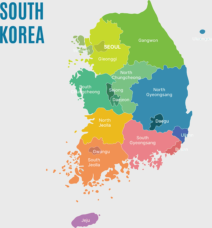
South Korea map, Seoul location, Gangwon province, Jeju island, Korean geography, regional divisions, administrative boundaries, png, PNG free download
South Korea map, Seoul location, Gangwon province, Jeju island, Korean geography, regional divisions, administrative boundaries, png
More related PNGs
1280x580pxred and white map illustration, Flag of Indonesia Brunei Map, greater Indonesia map, blank map with flag design, Southeast Asia political map, cartographic design elements, regional geography illustration
1062x399pxIndonesian Map, red map outline, travel World, cartography, Southeast Asia geography, archipelago nation, island nation map
2000x3000pxReligion in South Korea, South Korea map, Korean Buddhism, provinces of South Korea, Korean cultural geography, Korean religious landscape, Korean spiritual regions
3001x1099pxgrey Indonesia map, blank globe illustration, monochrome country map, flat design travel map, Southeast Asia geography, archipelago outline, island nation cartography
7506x8000pxIndia blank map, orange India silhouette, India world map design, stock India map, Indian geography outline, map of South Asia, India political borders
1217x912pxFlag of China, Provinces of China, red map, national flag, Chinese geography, Asian country map, star symbols
1024x1024pxFlag of Indonesia Map, black silhouette map, komodo travel, monochrome Indonesia map, Southeast Asia geography, archipelago nation, island nation outline
1024x1008pxFlag of Brazil, Ordem E Progresso, Brazil globe map, national flag, South American geography, Brazilian emblem, green and yellow design
700x838pxIndia Map illustration, India political map, blank India map, India state boundaries, Indian subcontinent geography, South Asia cartography, detailed India region map
444x701pxEngland Map UK, flag of the United Kingdom, map of Great Britain, blue and red design, British geography, UK political division, Union Jack overlay
900x900pxKarnataka Legislative Assembly election map, India political map, yellow Karnataka outline, Karnataka election results map, Indian state boundaries, regional election visualization, political geography of Karnataka
900x900pxNizamabad District Map, Telangana State Outline, India Political Map, Yellow Region Highlight, Geographical Borders, Administrative Division, Regional Cartography
892x906pxBrazil regions map, blank Brazil map, political map of Brazil, ecoregions of Brazil, South American geography, Brazilian states outline, map of Brazilian territories
742x866pxSouth America map, Latin America political map, blank Americas map, latino integration, South American geography, political boundaries Americas, continental map analysis
1024x1024pxflag of South Korea, Korean Peninsula conflict, national flag design, Korean War history, taegeuk symbol, trigram elements, east Asian iconography
578x578pxBrazil map, black and white map, mapa polityczna, travel world, South America geography, political division, country borders
512x512pxSouth Korea flag, Korean War history, taegeuk symbol, national flag design, Korean peninsula unity, East Asian culture, flag symbolism analysis
500x500pxJohnston Red Ginger, Port of South Louisiana, geolocation icon, red location marker, digital navigation symbol, map pointer graphic, business location emblem
1331x2930pxFlag of Argentina Map, argentina travel map, yellow sun emblem, blank map design, south america geography, national symbol art, argentine culture illustration
675x421pxMaharashtra map, Maharashtra state outline, Maharashtra geography, Maharashtra region, India state maps, map of Indian states, Maharashtra borders, png
446x729pxsouth Korean Presidential Election 1967 map, Seoul black and white silhouette, Korean Peninsula monochrome illustration, South Korea election geography, political history of Korea, historical election visuals, Asian political cartography
900x900pxKerala Map, India silhouette, blank Kerala map, travel Kerala, South India state, geographical outline, blue region map
1812x1114pxFalkland Islands map, Stanley Falkland Islands, Flag of the Falkland Islands, Port Louis Falkland Islands, Falkland Islands geography, Falkland Islands flag design, Falkland Islands political map
1280x625pxTokat Province map, Provinces of Turkey black and white, Istanbul region outline, Amasya location on map, Turkish geography illustration, blank Turkey provinces chart, Black Sea region cartography
2000x2670pxGran Colombia map, Flag of Colombia silhouette, Colombia national flag, yellow Colombia map, South American historical maps, Colombian geography visuals, historical flag designs
800x800pxsouth korea flag, national flag of south korea, korean flag design, flag of korea waive, korean symbol, east asian flags, korean heritage
2000x2729pxBangladesh blank map, districts of Bangladesh, division of Bangladesh, black and white map, geographical outline, administrative regions, country borders
2937x2645pxBrazil regions map, South Region Brazil geography, Southeast Region Brazil political division, North Region Brazil ecoregion, Brazilian state boundaries, map of Brazilian territories, Brazilian regional subdivisions
1200x1584pxColombia departments map, Putumayo Department outline, Boyacá Department geography, blank map of Colombia, Colombian regional boundaries, South American departmental divisions, cultural regions of Colombia
528x587pxPororo the Little Penguin, Kinder Chocolate, South Korea children's toys, Pororo and friends, animated animal characters, Korean children's entertainment, cartoon character merchandise
700x700pxFlag of Japan Map, Japan waves map, national Flag of Japan, red Japan map, Japanese geography, Asian cartography, island nation map
1024x377pxFlag of Indonesia Map, black and white map, Indonesia line art, monochrome travel map, Southeast Asia geography, archipelago illustration, political boundaries
359x768pxArgentina blank map, Argentine Northwest geography, black and white outline, coloring book map, South American cartography, silhouette map, travel atlas design
800x1200pxSouth Korean presidential election 2017 map, provinces of South Korea, black and white Korea map, South Korea blank map, Korean political geography, Korean election results visualization, Korean regional boundaries
1001x555pxRussia political map, карта россии, world map cartography, mapa polityczna Russia, Russian federation regions, geopolitical boundaries, Eurasian territories
2144x2308pxNorth Korea flag map, Korean Peninsula division, North Korean emblem, red star symbol, Korean political geography, national identity symbols, East Asian geopolitics
1100x479pxwhite and teal island illustration, United States continent map, beautiful world map design, seven continents map, global cartography art, 3D world geography, international travel map
498x560pxLatin America map, South America political map, black and white Americas map, world map with Latin America, geographic layout of South America, political boundaries of Latin America, monochrome continent map
518x518pxMalvinas Argentinas map, Falkland Islands dispute, Argentine Antarctica territory, blue world map, southern hemisphere islands, territorial sovereignty conflict, Antarctic region geopolitics
429x600pxFlag of Bangladesh Map, red and green flag, national Flag of Bangladesh, Bangladesh map flag, Bangladesh geography, South Asia map, Bangladesh flag design
512x512pxSouth Korea flag, Korean Peninsula flag, national flag of Korea, South Korean Taegukgi, Korean culture symbol, Asia country emblem, East Asian national identity
1437x1495pxAsia continental map, Asia Europe globe, mercator projection map, blank Asia map, world geography, global cartography, continental boundaries
1024x1024pxSouth Korea Ministry of Employment and Labor logo, blue national emblem, Korean government symbol, executive branch icon, Korean official seal, national identity mark, public service insignia
555x802pxPeru flag map, flag of Peru, Peru map outline, red and white flag, South American country flags, national symbol illustration, geographic boundary design
2400x1800pxMaharashtra Map illustration, UK geography, monochrome area diagrams, line art states, geographic boundary outlines, regional cartography design, geopolitical zone mapping
2000x2700pxKorean Empire Map, Flag of South Korea, korean unification flag, national flag, Korean peninsula map, historical Korean map, Korean cultural symbols
940x911pxSouth Korea flag, Korean national symbol, Korean War history, flag of South Korea, Korean cultural emblem, Korean patriotic design, Korean flag illustration
900x900pxLatin America map with flags, flags of South America, South America map, national flags of Latin America, Americas geography, South American countries, map of South American nations
688x838pxSouth America blank map, Central America monochrome map, Latin America line art, Americas geography illustration, political map of South America, educational map drawing, travel map of Americas
500x500pxYerba Buena Island South Korea, green leafed plant island, sea island icon, nature design, coastal vegetation, tropical island scene, eco-friendly island design
696x822pxFlag of South Korea, Korean War history, South Korea national symbol, white and red flag design, Korean peninsula map, East Asian cultural icon, national identity emblem
512x512pxSouth Korea flag, flag of South Korea, national flag of South Korea, Korean flag design, circular flag icon, flag emblem, South Korean symbol
943x1091pxblank India map, states and territories of India outline, monochrome Indian political map, central India geography, Indian borderlines illustration, subcontinental regions layout, location markers on India无声無息无声无息无声无息China
882x1280pxSouth America map coloring page, Latin America blank map, monochrome world map, black and white continent outline, educational geography illustration, printable line art map, travel world map design
1280x1280pxPalestine map, Gaza region, Palestinian flag, Middle East conflict, territorial boundaries, geopolitical area, national identity, png
356x766pxfinger heart gesture, Korean hand heart, Snuper heart symbol, South Korea heart sign, cartoon hand art, love gesture illustration, k-pop fan art
500x721pxPeru political map, Lima city map, black and white world map, map of Peru, South America geography, country borders illustration, travel destination guide
1428x732pxworld map mercator projection, monochrome political map, south-up world map, blank map for coloring, global geography illustration, international borders outline, cartographic design elements
640x640pxVenezuela flag map, administrative divisions of Venezuela, cryptocurrency Petro map, travel world Venezuela, political map of Venezuela, South American country map, Venezuelan flag design
4351x3416pxGujarat state map, Gujarat geographical layout, Gujarat district boundaries, Gujarat region outline, Indian state cartography, regional mapping, administrative divisions visualization, png
640x521pxSpain blank map, autonomous communities outline, black and white geography map, spain political regions, spain educational map, spain regional divisions, spain line art map
1644x2400pxColombia map, monochrome map, black and white map, travel world map, South America geography, political boundaries, regional divisions
2400x1454pxFalklands War map, Stanley Port San Carlos, Falkland Islands terrain, black and white topo map, South Atlantic conflict zones, British overseas territory map, Argentine military operations
1242x1128pxflag of brazil map, map of brazil, brazilian geography, world map graphic, 3D map illustration, cities in brazil, south america political map
1024x1024pxRajasthan map, blue map outline, travel world map, blank map template, geographical region, state boundary, cartographic design
1928x1920pxBrazil map flag, Brazilian flag design, Brazil country outline, Brazil national symbol, South America geography, green and yellow emblem, Ordem e Progresso motto
3333x3146pxflag of Pakistan map, Pakistan topographic map, Pakistan independence day, Pakistan geography, Pakistani cultural symbols, South Asian cartography, national emblem design
2290x2285pxFlag of Greece map, Greek national symbol, Greece travel world map, Greek flag overlay, Hellenic geography, Mediterranean country borders, Aegean region cartography
512x512pxSouth Korea map, Korean Peninsula silhouette, black and white map, monochrome travel map, Asia geography, country outline, peninsular region
612x416pxMexico State Puebla map, administrative divisions of Mexico, black and white map, Puebla Mexico State, Mexican geography, state boundaries, regional cartography
2000x2208pxSanta Cruz Department map, Departments of Bolivia Atlas, blank map of Bolivia, line Art map, Bolivia political divisions, South American geography, Bolivian department boundaries
988x1293pxKorean Unification Flag, korean peninsula map, south korea flag design, north korea world map, korean culture symbols, east asia political geography, interkorean relations visualization
1463x1238pxEurope Map, blue silhouette map, travel world map, European geography, continent outline, cartographic design, regional borders
1280x1280pxcounties of Croatia map, Croatian border flag, Dalmatia region, Slavonia area, Croatian historical regions, European country divisions, Croatian administrative boundaries
733x517pxsouth korean flag, south korea national symbol, korean banner, south korea emblem, taegeukgi design, korean cultural icon, east asian flag